


SERVICES
AERIAL PHOTOGRAPHY AND IMAGING
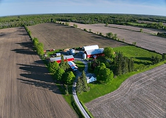
Innovation Drone provides professional aerial photography and imaging services for businesses, landowners, and organizations looking to capture high-quality views from above. Drone photography offers a unique perspective that highlights properties, projects, landscapes, and infrastructure in ways that traditional photography cannot.
Using advanced drone technology, we capture high-resolution images that can be used for marketing, documentation, inspections, and project presentations.


Our Photography Drone
Aerial Imaging Drone
-
DJI Mavic Pro
This drone is equipped with a high-resolution camera capable of capturing detailed aerial images and videos from multiple angles, providing clear and professional visuals for a variety of applications.

Real Estate Photography
Aerial photography is an effective way to showcase properties and land features.
Applications include:
-
Residential property marketing
-
Rural property and farmland overview
-
Commercial real estate promotion
-
Land development projects
Drone imagery provides potential buyers with a clear perspective of the property layout and surrounding environment.
Project & Site Documentation
Drone photography is widely used to document projects and operational sites.
Applications include:
-
Construction project progress
-
Infrastructure documentation
-
Mining and quarry operations
-
Agricultural field overview
These images provide a visual record that can be used for reports, planning, and project management.


Marketing & Promotional Imagery
Professional aerial images are powerful tools for marketing and communication.
Applications include:
-
Business marketing materials
-
Website imagery
-
Social media content
-
Tourism and promotional campaigns
Aerial photography helps businesses present their operations and locations in a visually compelling way.
Land & Property Overview
Drone imagery can capture large areas of land quickly and clearly.
Applications include:
-
Farm and rural property documentation
-
Land management overview
-
Property boundary visualization
-
Environmental monitoring
This perspective allows landowners and businesses to better understand and document their property.
